 First Due Tackle Pass It On – Firefighter, Rescue & Extrication Training
The Sandusky Fire Department shared some information about the Great Lake rip currents the other day. It just so happens that the weather is right and a North East blow is making the southern shore of Lake Erie treacherous today in our area (Huron, OH – halfway between Cleveland and Toldeo).
“LIKE” FIRST DUE TACKLE ON FACEBOOK
According to the U.S. National Weather Service, Weather Forecast Office, from 2002-2012, a total of 44 rip current and channel current related incidents (26 deaths, 18 rescues) have occurred on Lake Erie alone. Similarly to Lake Michigan, Lake Erie sees most of the current related problems near the most populated regions and a majority of the incidents have occurred at beaches with structures such as piers and breakwalls.
Lake Erie is the shallowest of all the Great Lakes, which means the influence of weather on the lake is greater. As a result, Lake Erie has more rip current related incidents associated with seiches (water sloshing back and forth in a basin) than all of the other lakes. Lake Erie tends to see rip current development during the passage of a cold front, which brings strong onshore winds just before, during and after its passage. These stronger winds help to generate larger waves quickly, especially with the shallow waters of Lake Erie. With much shallower water, wave heights do not need to be as high to cause rip current development, especially with the added complexity of seiche-like motions, which can act like a tide on the ocean.
Looking at the areas where rip current related incidents were most frequent on Lake Erie, a common thread is deduced. Rip currents on the ocean and in the Great Lakes frequently occur in regions with complex sandbar features, river mouths (or other outlets), and shoreline structures. At least one of those qualifying features is seen in all of the incident locations on Lake Erie.
The image provided shows the locations with the highest numbers rip current related incidents on Lake Erie.
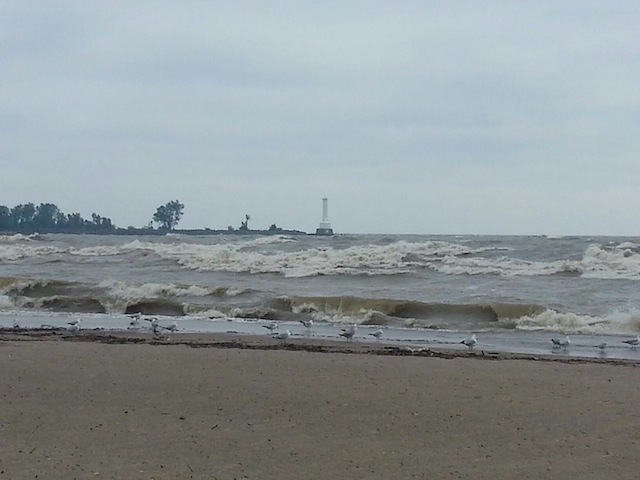
The picture above was taken this afternoon at Nickel Plate Beach in Huron, OH. This beach makes the list for dangerous rip currents as seen in the center picture below.
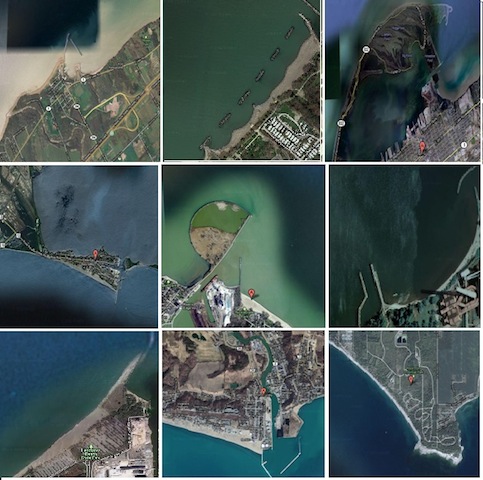 Top Row:
Left = Chatauqua, New York
Center = Euclid Beach, Ohio
Right = Presque Isle, Erie, Pennsylvania.
Center Row:
Left = Erieau, Canada
Center = Nickel Plate Beach, Huron, Ohio
Right = Miller Road Park, Avon lake, Ohio
Bottom Row:
Left = Headlands Beach State Park, Mentor, Ohio
Center = Port Stanley, Ontario, Canada
Right = Rock Point Provincial Park, Ontario, Canada
Find out more on seiche’s at; http://1.usa.gov/17CepsE
Information shared from the U.S. National Weather Service.www.crh.noaa.gov/mqt/?n=lakeerieripcurrenthistory
Pass it on!